Relative volume percentages of an ideal, undisturbed soil (left) and disturbed, compacted soil (right). When land is developed and vegetation removed, soil often has a greater percentage of solids than pore space (including water and air) due to compaction. This can limit infiltration and increase surface runoff. Source: USDA-NRCS Montana
In general, soils are made of both solids and pore space. A soil is ideally 50% solids and 50% pore space by volume. The solids can either be minerals from weathering rocks or organic matter from vegetation and organisms that live inside of the soil. Most solids come from rock minerals unless the soil is developed within a wetland, in which case there is much greater organic matter content. Additionally, the pore space of soils can either be filled with air or water. The percentage of air and water varies depending on how much water is applied to the soil. Overall, the balance between solid and pore space volume in a soil is constantly changing. Typically plant roots help make larger pores that help increase the volume of pore space, which also helps the soil act like a sponge to infiltrate and absorb rain. However, when vegetation is removed and the soil is disturbed during land development, compaction often takes place, and soil pores often compress and pore channels within the soil get cut off. This severely limits infiltration and water absorption, thus increasing surface runoff.
In conventional agriculture, the surface of the soil gets turned over once a year with conventional tillage practices. This tillage breaks down any soil structure that was once held together by plant roots. This alters soil pore systems, limiting soil water movement and infiltration. In addition, farm equipment can be heavy, and with passes over the field, this equipment can compact the soil, which result in hard pans in the subsoil. Compaction also limits water infiltration. With limited infiltration, rainwater often starts to pool on the soil surface and starts running downhill.
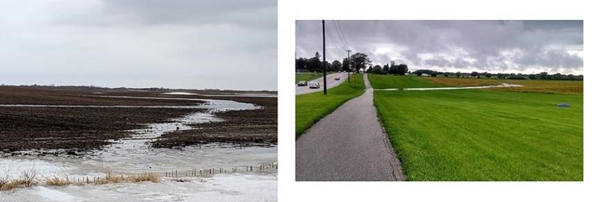
Concentrated flow path (CFP) on very flat ground with little vegetative cover due to conventional tillage (left). This picture emphasizes that water will find its way downhill, even on the flattest of ground. CFPs often come from natural topography with water collecting as shallow concentrated flow in the lowest portions of the landscape (right). Source: Tyler Groh, Penn State
When water starts to runoff, it is often as a thin layer. This is called sheet flow. As the name implies, you can imagine a thin bed sheet of flow gliding across the surface of the soil in which it has contact with. The smoothness and extent of this sheet flow often depends on surface roughness-how bumpy the soil is on the surface (Darboux et al., 2002). A tilled field can be smooth with little vegetation from the previous year’s crop. Sheet flow will last for a maximum of 100 feet before it turns into shallow concentrated flow (USDA-NRCS, 2010). Shallow concentrated flow can occur as rills or gullies and are collectively called concentrated flow paths (CFPs). These CFPs often occur in draws and swales that occur naturally due to topography. CFPs can carry large amounts of both nutrients and sediment from soil erosion as well as large quantities of water to surface water bodies. If left unchecked, CFPs can form eroded gully channels on the landscape and remove most of the fertile topsoil and produce huge channels that make farming dangerous when using large equipment.
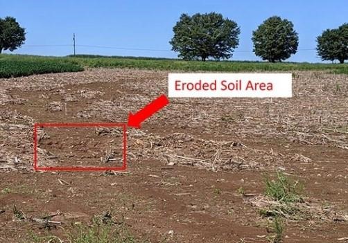
The evidence of a CFP after a large rain event. The corn stover (left over corn stubble on the field after harvest) is washed off the surface, and the soil is starting to erode off the surface (red box). If left untreated, this CFP could form a large gully over time. Source: Tyler Groh, Penn State
Large CFPs, like those that form gullies can also easily overwhelm agricultural conservation practices like riparian buffers. Riparian buffers are strips of perennial vegetation around a surface water body, often creeks, that protect the water from directly adjacent land uses. Buffers are designed to help absorb any surface runoff. Riparian buffers are only able to effectively do this when the water enters as sheet flow (Knight et al., 2010). Once water collects as shallow concentrated flow and forms CFPs, it may bypass much of the riparian buffer planting and enter directly into the creek.
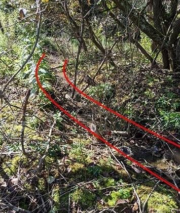
The red lines outline a CFP which flows through a riparian buffer. This CFP has actually formed a gully within the buffer, and may be adding to the amount of sediment within the creek instead of filtering this sediment. Source: Tyler Groh, Penn State
Both sheet and shallow concentrated flow may erode soil from the surface if left unchecked. So, what can be done to protect creeks and other surface water bodies from CFPs? It all starts with in-field management. One of the best ways to conserve both soil and water resources on agricultural land is to mimic nature within crop rotations and soil management. Most of the surface area in natural landscapes, like forests, are covered by vegetation, and during the growing season this vegetation is constantly putting down and maintaining new and old roots and producing vegetative, above ground growth to close the canopy. In addition, forests have understory vegetation with many stems to slow the velocity of water that may travel over the surface of the soil. Slowing water runoff velocity reduces the energy of the water, lessening the chances of soil erosion.
Best management practices in agronomic systems try to mimic this natural system by relying on cover crops and extended crop rotations to keep living roots and live, growing plants in the ground for as long as possible. These plants help increase evapotranspiration of a field, protect against soil erosion, and help slow sheet and shallow concentrated flow down. If water were to flow across a field with cover crops, it must do so by running into each stem of each plant it encounters (Dabney, 1998). This contact slows the water velocity and allows water to spread out over the land instead of concentrating over a short distance. Another way of spreading water out to avoid gully formation is by using no-till or conservation tillage to allow crop residue to stay on the soil surface between plantings. This residue, especially corn stover, will make a rough surface for the surface water to pass over, thus spreading the water.
Crop residue from last year’s planting can help spread surface water out over a field, helping protect against gully formation from CFPs. No-till or conservation tillage is needed to have this amount of crop residue. This practice is most effective on relatively flat ground.
Similarly, having a warm season grass zone on a riparian buffer that is directly between the crop field and the planted riparian trees can help spread out some of the water that flows off the land surface in CFPs. The combination of the warm season grass zone and the riparian woody vegetation make a great one-two punch to help slow and treat surface runoff water. The grasses can effectively slow the water, while the woody vegetation help make large and deep soil pores to increase water infiltration. Wider buffers are also better at absorbing more surface water due to the longer linear path they create. However, widths of buffers ultimately depend on the available space in a field.
In summary: yes, water flows downhill, and it is incredibly hard to manage all the rain from a large storm event. However, nature provides us a great example of how to manage our land, and it all starts with having living vegetation on the field for as long as possible throughout the year. This vegetation in combination with conservation tillage practices can greatly reduce the risk of excessive water lost from fields and limits soil erosion.
Source : psu.edu