Forecast: Low pressure across Kentucky may lead to a few isolated showers and storms for Tuesday and Wednesday, mainly across the eastern half of Ohio. High pressure will take control for Thursday and Friday, before the next cold front slowly moves in and lingers throughout the region for Saturday through Monday. This front will likely kick up a few showers and storms for the weekend. Temperatures will remain seasonally mild this week, with highs in the upper 70s to mid 80s and overnight lows in the upper 50s to mid 60s. The Weather Prediction Center is forecasting 0.25-1.0 inch of rain over the next 7 days (Figure 2).
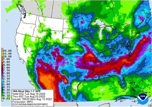
Figure 2). Precipitation forecast from the Weather Prediction Center for 8pm Monday Aug 15 – 8pm August 22.
The Climate Prediction Center’s 6–10-day outlook for the period of August 21-25, 2022 and the 16-Day Rainfall Outlook from NOAA/NWS/Ohio River Forecast Center show near to below average temperatures with above average precipitation are expected (Figure 3). Climate averages for the period include a high-temperature range of 82-86°F, a low-temperature range of 61-65°F, and average weekly total precipitation of about 0.75 inches.
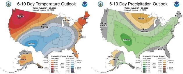
Figure 3) Climate Prediction Center 6-10 Day Outlook valid for August 21 – 25, 2022 for left) temperatures and right) precipitation. Colors represent the probability of below, normal, or above normal conditions.
Source : osu.edu