Overall, 1-3” of liquid-equivalent precipitation has fallen over the state during the last two weeks (Figure 1). This has helped streamflows and soil moisuture start to recover, though further improvements are needed ahead of the upcoming planting season. For the latest up-to-date conditions, seasonal outlooks, and monthly climate summaries, please visit the State Climate Office of Ohio.
Forecast
A cold front will start to approach the region on Wednesday with rain showers likely but high temperatures well above average in the 50s and 60s. Cooler air will filter into the state for Thursday with a few scattered rain and/or snow showers possible and highs in the 30s and 40s. Friday should be dry before another system moves toward the Ohio Valley. There is some uncertainty regarding precipitation type, with the potential for some minor snow accumultion across northern Ohio. The forecast is likely to flucuate over the next several days. This system will move out by Sunday with high pressure taking over. Temperatures will remain closer to seasonal normals, with highs in the 30s and 40s and lows in the 20s and 30s throughout the upcoming weekend. Overall, the Weather Prediction Center is currently forecasting 0.10-1.0” (west to east) of liquid-equivalent precipitation over the next 7 days.
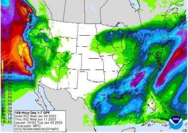
Figure 2). Precipitation forecast from the Weather Prediction Center for 7pm Monday January 3 – 7pm Monday January 10, 2022.
Guidance continues to suggest that despite temperatures cooling off a bit, they are likely to remain above normal. The Climate Prediction Center’s 8-14-day outlook for the period of January 11 -17, 2023 and the 16-Day Rainfall Outlook from NOAA/NWS/Ohio River Forecast Center show a strong probability of above normal temperatures with precipitation leaning below normal (Figure 3). Climate averages include a high-temperature range of 34-39°F, a low-temperature range of 20-24°F, and average weekly total precipitation of 0.55-0.85 inches.
Source : osu.edu