By Laura Edwards
Current Conditions
As the flood waters slowly recede across South Dakota, farmers and gardeners are anxious to get their seeds and plants in the ground this spring season. A month ago at this time, the Southeastern areas were recovering from rain and rapid snowmelt from the March 13-14 storms and flooding. Much of the rest of the state was still under a blanket of deep, wet snow over frozen soils.
Figure 1. Soil moisture “poker chip” map for SD Mesonet weather stations. Each disc or “chip” represents soil moisture at each depth. Soil moisture measurements are taken at 2, 4, 8, 12, 20, and 40-inch depths.
As of May 3, the snow cover has melted in all but the Black Hills area and soils have thawed out quickly, according to the
SD Mesonet. Soil moisture, however, is still quite high in many Southern and Eastern locations. The moisture from 2018 and into the fall season had left soils nearly saturated, even before the snowy and wet winter and spring of this year. Even areas that have had a couple of years of drought in the Central part of the state have recovered top soil moisture well this spring. Deeper layers are still showing some drier soils in 20-to-40-inch depths, as a residual from years of drought.
May Outlook
PRECIPITATION
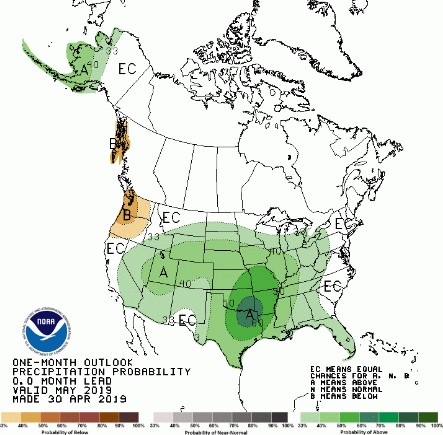
The precipitation outlook for May does not show much promise of relief from moisture, as wetter than average conditions are slightly more favored than drier conditions. The NOAA Climate Prediction Center update on April 30, 2019, has elevated chances of wetter than average conditions for much of the country. In particular, the first two weeks of May are projected to bring the jet stream over South Dakota, which means several small precipitation events are likely. With this active weather pattern, every couple of days will have a chance of precipitation, leading to limited opportunities for soil to dry out in preparation for planting of field crops. As May is one of the wettest months of the year, wetter than average conditions will make crop progress and planting in fields and gardens especially challenging.

Figure 2. Precipitation outlook for May 2019, updated on April 30, 2019. Green shaded areas are favored to be wetter than average for the month of May. Darker shades indicate higher confidence or probability.
TEMPERATURES
In addition, cooler than average temperatures more likely for the first half of May and could continue for much of the month. The temperature outlook for the month overall also favors cooler temperatures. As of May 3, soil temperatures at 4-inch depth are hovering around 45-50 degrees F. As cooler temperatures return in the second week of the month, these soil temperatures will cool down again and become less favorable for planting corn and some garden plants. For corn, it is recommended to wait until a 3-day average soil temperature is 50F or higher for best germination to occur.
River Levels
The James River through South Dakota is in Major flood stage in early May and is expected to remain in some level of flood stage for many weeks yet. The crest has likely already passed through the upper basin, as stream gauges and the forecasts are indicating steadily lowering levels above Forestburg. It is forecast that the last crest will pass through the mouth of the James River at the Missouri River in mid-May.
The Big Sioux River is also steadily falling and is in Moderate flood stage in early May. It is likely that the peak for this season has already passed, but Minor to Moderate flood stage will likely continue through the next several weeks.
One thing to remember as we come out of peak snowmelt season is that flood risk is not over. With saturated soils and rivers and creeks still at high levels, a flash flood can occur very rapidly. Even a “moderate” thunderstorm of less than an inch of rain can run off soils quickly and cause flash flooding across roads, fields, or poorly drained areas and raise rivers.