Her Texas Water Development Board project is collecting soil samples at sites throughout Texas. These sites are part of the TexMesonet, a network of environmental monitoring stations that have collected meteorological and soil moisture data around Texas every 15 minutes since 2016. The new project aims to determine how much of that water is actually available for plant production.
“Our goal is to characterize the physical properties of the soils at these sites so that we can develop data products for the public to use,” Wyatt said.
This data will provide the site-specific information required for utilizing measured soil moisture data in applications such as drought monitoring and prediction, streamflow and flood forecasting, irrigation management, estimating potential groundwater recharge, and wildfire prediction, among others.
Determining available water capacity and more
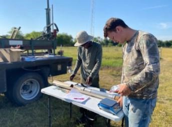
Bismark Osei, a master’s student using the study as his thesis project, and Jarod Raack, an undergraduate student in biological and agricultural engineering working on the project as an intern, started visiting 90 sites all over Texas in May. The two students go to a new site each week to take samples.
 Taking soil samples at a TexMesonet site are Bismark Osei, left, a master’s student, and Jarod Raack, right, an undergraduate student in biological and agricultural engineering. (Texas A&M AgriLife photo by Briana Wyatt)
“We will continue our fieldwork until all of the sites have been sampled,” Wyatt said. “We have to have the samples to characterize the physical properties of the soil at each site and create a database of those properties. Then we will combine that information with the soil moisture sensor output at each site to create statewide soil moisture maps that are easy for the general public to use.”
Wyatt said the combination of the soil’s physical properties and the soil moisture data will allow the estimation of several variables, including the fraction of available water capacity, or FAW. This derived variable represents soil moisture conditions on a scale from 0-1, where 0 indicates that the soil is very dry and 1 indicates it is very wet. This index is useful for practical applications, and an FAW value of 0.5 is traditionally considered the threshold value at which agricultural producers should irrigate their crops.
“The general public can then use that information for irrigation scheduling,” she said. “The soil moisture data also can be used for streamflow forecasting or estimating groundwater recharge and many other applications.”
This is Wyatt’s second time working on a soil characterization project that builds on data from a mesonet. These valuable networks of automated stations are named for their measurements of mesoscale, or mid-range, weather systems.
“Oklahoma has what is widely considered to be the ‘gold standard’ of mesonets, and I did similar work there during my graduate studies, so I was interested in replicating that work here,” she said. “It takes quite a long time to cover the entire state and collect the samples – it takes a month to run each sample in the lab, and it takes a lot of time and programming skill to create a good map.”
A secondary goal of the project is to improve the visibility of available soil moisture information and products and thus the awareness and utilization of TexMesonet soil moisture information by researchers, water managers and the citizens of Texas.
Source : tamu.edu