June 2023 Outlook
TEMPERATURE
The outlook for the end of May and early June indicates temperature in South Dakota is most likely to continue above average at least through the first week of June. As of this writing, the temperature outlook for the month of June from NOAA’s Climate Prediction Center indicates odds tilting towards warmer than average for the month overall. For agriculture and gardening, this could mean faster plant development in the fields and yards, and also more-rapid development of weeds and insects that respond to temperature, such as alfalfa weevils.
PRECIPITATION
The month ahead looks less clear as far as precipitation patterns go. The precipitation outlook for June shows the southwest corner of South Dakota with increased chances of wetter than average conditions. The rest of the state has equal chances of wetter, drier or near-average moisture for the month. This is indeed the pattern that is beginning to form for the early part of June.
June Through August Outlook
A look ahead at the next three months shows even more uncertainty than the month of June alone. One climate factor for the summer season is a rapidly developing El Niño, that has the potential to be stronger than most El Niño events in the last several decades. El Niño does not often have much impact in the summer, as it is typically strongest in the winter season. This year appears to be very unusual, as sea surface temperatures in the Pacific Ocean are already quite warm. One large element of uncertainty comes into the atmospheric response to the ocean temperatures. We have not observed the atmosphere “couple” or respond to the very warm ocean temperatures yet, and so forecasters are less confident in the impact of El Niño this summer.
TEMPERATURE

Figure 1. June through August 2023 temperature outlook. South Dakota has equal chances of warmer, cooler, and near-average temperatures. Courtesy: NOAA
What we know from past summer seasons with El Niño is that they are often slightly cooler than average in South Dakota. This conflicts with our long-term trend of slightly warming in the summer months, and as a result, the temperature outlook for June through August shows equal chances of warmer, cooler or near-average temperature for those three months overall.
PRECIPITATION
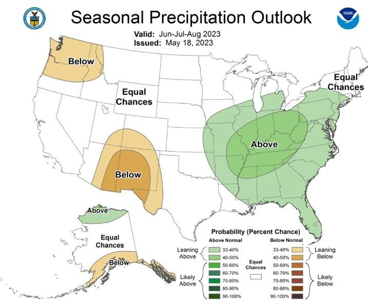
Historically, El Niño in the summer season has brought a combination of wetter conditions in western South Dakota, and often drier conditions in the northeast. However, these are very small differences and don’t bring much confidence to the forecasters. These small differences compound the usual challenge of forecasting summer season precipitation, which is often difficult with local thunderstorms that dominate the summertime climate in South Dakota. As a result, all of South Dakota is indicated to have equal chances of wetter, drier or near-average precipitation for the three months of June through August overall.

Figure 2. June through August 2023 precipitation outlook. South Dakota has equal chances of wetter, drier or near-average precipitation for the June through August time period. Courtesy: NOAA
In summary for the upcoming three months, it is possible to see a lot of variability throughout the season this year. There have not been many, if any, clear indicators on either temperature or precipitation.
Drought
The topic of drought has been in daily discussions over the last couple of years. A wet winter and some local rainfall this spring has improved conditions in many areas, but the east continues to struggle with moisture in May. For the first three weeks of May, the southeast and eastern regions of the state have had 25 to 50 percent of average precipitation. Some areas are around 50 to 70 percent of average. Typically, in May and June, precipitation averages about .75 to one inch per week, so deficits can build quickly this time of year. In the west, Mother’s Day weekend (May 13 through 14) brought three to six inches of rain to many areas, but conditions have been primarily dry since then.
Row crops and seedlings in gardens do not typically need a lot of moisture this time of year, but they do need to maintain some moisture in shallow soils for good germination and early plant development. The lack of regular, seasonal rainfall may be setting the stage for some drought development, just as many areas came out of drought earlier this spring. During the growing season, heat (and also wind) can make dry conditions worse, by increasing the moisture demand of crops, lawns and gardens. If you have irrigation available, watch those fields, yards and gardens closely for signs of drought stress, as you may need to increase your irrigation or watering. Water trees and shrubs also to avoid drought stress from developing.
Source : sdstate.edu