Topsoil moisture condition rated 6 percent very short, 22 percent short, 68 percent adequate and 4 percent surplus. Subsoil moisture condition rated 10 percent very short, 34 percent short, 55 percent adequate and 1 percent surplus.
Oats seeding reached 20 percent complete, 8 days behind last year but 2 days ahead of the 5-year average. Oats emerged reached 2 percent.
Calving was in full swing with reports of mud in some areas.
Weather Summary
Provided by Justin Glisan, Ph.D., State Climatologist, Iowa Department of Agriculture and Land Stewardship
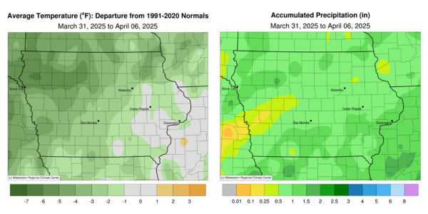
April began with unseasonably wet conditions across the state with stations in northwest and southern Iowa reporting over 200% of normal rainfall. Temperatures for the first reporting period of the season were colder than average over Iowa’s northwest corner while near-normal conditions were found southeast; Iowa’s average temperature was 40.7 degrees, 2.6 degrees below normal.
A low pressure system continued its path through eastern Iowa on Sunday (30th) afternoon as blustery northwesterly winds built in behind. Rain was reported over much of the state with the highest totals from central to northwest Iowa; Battle Creek (Ida County) reported 0.68 inch while a 0.70-inch total was observed in Webster City (Hamilton County). Measurable snow also accompanied the system with measurements ranging from 0.1 inch in Ames (Story County) to 4.0 inches at Fort Dodge (Webster County). Skies remained mostly cloudy to overcast into Monday (31st) with morning lows in the upper 20s and low 30s. Clearing into the afternoon helped boost highs into the low 50s in southern and eastern Iowa while low to mid 40s blanketed northwestern Iowa. Winds shifted to the east into Tuesday (1st) morning as clouds moved in over western Iowa ahead of another low pressure disturbance. A few waves of moderate rain showers crossed the state into early Tuesday (2nd) morning with stronger thunderstorms firing in western Iowa just after midnight, producing scattered large hail reports. Rain persisted just before noon with a narrow line of thundershowers in northeastern Iowa during the early afternoon. High temperatures rose into the upper 60s to mid 70s in the southeast, nearly 20 degrees above normal. Event rain totals registered at 7:00 am on Wednesday (3rd) showed that most Iowa stations observed at least 0.50 inch with over 70 locations receiving an inch or more. The highest totals were found in northwest eastern Iowa with the Davenport NWS office measuring 1.44 inches. In the northwest, Fonda (Pocahontas County) collected 1.53 inches with an overall statewide average of 0.76 inch. Clouds held over northern Iowa though the afternoon and evening hours with daytime temperatures in the 40s; sunshine across southern Iowa pushed temperatures into the low 50s with light winds.
Winds swung around to the east into Thursday (4th) as partly cloudy skies held lows in the mid 30s over portions of central and western Iowa. Showers associated with a strong surface low moving across the Ohio Valley filtered into southern Iowa during the afternoon hours and lingered into eastern Iowa through late evening. Rain amounts were generally light with the highest totals ranging from 0.20 inch in Mount Union (Henry County) to 0.34 inch in Bloomfield (Davis County). Parts of western Iowa experienced light rainfall as a cold front crossed the state into Friday (5th). Gusty northerly winds developed behind the boundary with overnight lows ranging from the upper 20s northwest to low 40s southeast. Afternoon temperatures stayed in the low to mid 40s as skies cleared with strong northerlies persisting past sunset. Starry skies and light winds allowed substantial surface cooling, resulting in lows in the 20s; the statewide average low was 25 degrees, 10 degrees below normal. Daytime highs rebounded nicely into the mid to upper 50s under variable winds and bright sunshine. A fast moving cold front moved through the Upper Midwest overnight into Sunday (6th), shifting winds back to a northerly direction with upper 20s to low 40s north to south across Iowa.
Weekly precipitation totals ranged from 0.14 inch in Earling (Shelby County) to 2.03 inches in Fonda. The statewide weekly average precipitation was 0.88 inch; the normal of 0.67 inch. Multiple eastern Iowa stations reported the week’s high temperature of 75 degrees on the 2nd, on average 17 degrees above average. Audubon (Audubon County) reported the week’s low temperature of 18 degrees on the 6th, 14 degrees below normal. Four-inch soil temperatures were in the low to mid 40s statewide as of Sunday.

Source : iowaagriculture.gov