By Alvaro Garcia
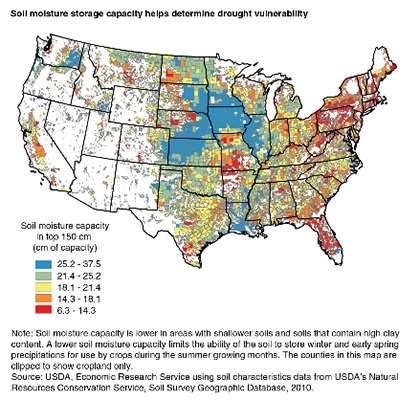
Most of the Great Plains have always been considered a semi-arid area of the U.S. This Region is characterized by hot, relatively short summers (with a rainfall pattern), and usually cold, dry winters. Annual precipitation increases by almost 70 percent between the Western (East of the Rockies) and Eastern ends of the Region. Potential moisture losses by evapotranspiration also increase by almost 400 percent between the Northern (Canadian border) and the Southern extremes. In addition to these moisture gradients, agricultural production is challenged by high climate variability interspersed with periods of severe precipitation shortages. Susceptibility to drought is not only determined by the yearly precipitation but also by the moisture storage capacity of the different types of soil. The map shows that west of the Missouri river the moisture storage capacity is low compared to the east, which is similar to other highly crop-producing regions of the Midwest. Even during years of normal rainfall there can be short-term dry periods that can affect crops.

Long-Term Drought Projections
In a February 2015 report NASA suggested severe droughts in the Central Plains during the last half of this century could be more extreme and longer than those verified in the last 1,000 years. The agency further stated the dry spell would probably last for as long as three decades. The map below shows that depending on the location in the state the best scenario has been a drought every 5 years for Northeast South Dakota, followed by almost one every 4 for East Central and Southeast, one every 3 for South Central and Southwest, and one every 3 to 2 for the North Central and Northwestern part of the state. If what NASA predicts for the future should become a reality, additional management strategies will have to be utilized in the Great Plains. Agriculture practices will have to adapt to production systems already common in areas where precipitation or even water supply is frequently limiting.