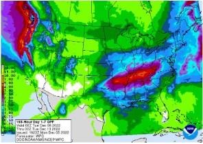
Figure 2). Precipitation forecast from the Weather Prediction Center for 7pm Monday December 5 to 7pm Monday December 12, 2022.
Forecast
The first in a series of storms this week will be on-going Tuesday morning. Periods of rain showers are expected across the state through Wednesday morning then again Thursday afternoon through Friday night. Temperatures over this stretch will start out with highs in the 40s and 50s, cooling off into the 30s and 40s for the weekend. Another system will start to impact Ohio by Sunday afternoon into Monday. Overall, the Weather Prediction Center is currently forecasting 0.50 (north)-2.00 (south) of precipitation across Ohio this week (Figure 2).
The Climate Prediction Center’s 8-14-day outlook for the period of December 13 – 19, 2022 and the 16-Day Rainfall Outlook from NOAA/NWS/Ohio River Forecast Center have temperatures near to above normal and precipitation leaning wetter than normal (Figure 3). Climate averages include a high-temperature range of 42-46°F, a low-temperature range of 26-30°F, and average weekly total precipitation of 0.55-0.85 inches.
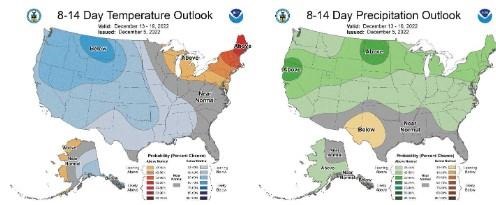
Figure 3) Climate Prediction Center 8-14 Day Outlook valid for December 13 - 19, 2022, for left) temperatures and right) precipitation. Colors represent the probability of below, normal, or above normal conditions.
Source : osu.edu