There is not much in the way of precipitation relief this week for the driest areas of the state. High pressure will remain in control through Thursday, before the combination of a strong cold front moving in from the west and tropical moisture surging northward ahead of the front could bring showers into the region on Friday. Much colder air, highs generally in the 30s and 40s and overnight lows in the 20s will follow for the weekend. Lake effect rain and snow will continue for the northeast as well. The Weather Prediction Center is currently forecasting up to 1.00” of precipitation across eastern counties of Ohio this week (Figure 2).
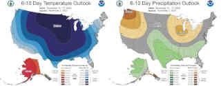
The Climate Prediction Center’s 6–10-day outlook for the period of November 13 - 17, 2022 and the 16-Day Rainfall Outlook from NOAA/NWS/Ohio River Forecast Center show a major weather pattern shift, with below normal temperatures likely but precipitation still leaning below average for the period (Figure 3). Climate averages include a high-temperature range of 52-56°F, a low-temperature range of 34-38°F, and average weekly total precipitation of 0.65-0.85 inches.
Crop Observation and Recommendation Network
C.O.R.N. Newsletter is a summary of crop observations, related information, and appropriate recommendations for Ohio crop producers and industry. C.O.R.N. Newsletter is produced by the Ohio State University Extension Agronomy Team, state specialists at The Ohio State University and the Ohio Agricultural Research and Development Center (OARDC). C.O.R.N. Newsletter questions are directed to Extension and OARDC state specialists and associates at Ohio State.
Source : osu.edu