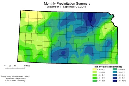
September precipitation – Large variation across Kansas
Average divisional precipitation ranged from 0.98 inches in the Northwest Division to 4.36 inches in the North Central. This resulted in a 0.56 inch deficit in the Northwest (61% of normal) and a 1.73 inch surplus in the North Central division (164% of normal). Statewide average was 1.36 inches, which is a 0.66 inch surplus, or 133 percent of normal. The greatest monthly total for a National Weather Service Cooperative station was at Marysville, Marshall County, with 12.23 inches. The Community Collaborative Rain, Hail and Snow (CoCoRaHS) network station with the greatest monthly precipitation was Manhattan 3.7 N, Riley County, with 11.37 inches. Among the Kansas Mesonet stations, the Manhattan station at the Agronomy North Farm, had the greatest monthly total with 8.00 inches. Most of the rainfall occurred during the first week of the month, particularly over the Labor Day weekend. The flooding produced by the intense rains resulted in a Governor’s disaster declaration that covered five counties: Jewell, Kingman, Marshall, Pratt, and Riley.

Temperature variations for September
Temperatures across Kansas for September were also highly variable. Statewide average temperature for the month was 69.9 degrees F, which is 1.8 degrees warmer than normal. All divisions were warmer than normal. The Northwest Division had the largest departure, with an average of 67.9 degrees F, or 2.6 degrees warmer than normal. The South Central Division came closest to normal with an average of 71.3 degrees F or 1.1 degrees warmer than normal. The variability showed in the range of temperatures. The warmest maximum temperature was 105 degrees F at Johnson, Stanton County, on the September 1. The coldest minimum temperature was 30 degrees F, recorded at Brewster 4W, Sherman County, on the 27th. There were 10 record daily high maximum temperatures in the month, and 10 record daily low maximum temperatures. On the minimum temperature side, there were 27 record high minimums compared to only one record low minimum.
September severe weather
While hail and high winds were again major contributors to severe weather in Kansas during September, the big story was the Labor Day flood event. Damage in these counties featured washed out roads, bridges, culverts and flooding to some businesses and residential properties. Complete damage estimates are not yet available. There was one tornado report during the month consisting of land spout funnels in Hamilton County, on September 3. They were short lived.
Drought update
The near normal temperatures in the west moderated the impacts of below-normal precipitation. Drought was completely removed from the west and greatly improved in the central divisions. Exceptional drought continues in eastern Kansas, and extreme drought has shifted into east central Kansas. Currently, over 77 percent of the state is drought-free, while under 1 percent is in exceptional drought conditions. The October outlook has increased chances for above-normal precipitation across most of the state. However, a more even distribution across the month will be needed to continue improvement of drought conditions across the state. The temperature outlook is for warmer than normal temperatures statewide.