The RAP is a free online resource that provides easy-to-access data on vegetation trends across the West from the mid-1980s to the present day. Plus, this web application calculates how productive those plants are. A combination of long-term datasets show landowners how their lands have changed over time, which translates directly into how profitable their operation is.
“We can finally quantify outcomes of rangeland conservation in terms of dollars and cents,” says Tim Griffiths, western coordinator for the USDA Natural Resources Conservation Service’s Working Lands for Wildlife.
Closing the gap to boost grass growth
Farmers in the central and eastern U.S. have been using technology to closely track changes in crop production for decades. As soon as they see data showing that their plant productivity is declining — and revenues following suit — they can take steps to address the limitations and boost productivity again.
RAP provides the same power to ranchers.
This technology can show ranchers the gap between their potential production and the actual production they realize in terms of pounds-per-acre of grass (typically called “yield gap” in farming circles). It helps landowners understand how much they can potentially gain by changing management practices to boost available forage and close the gap.
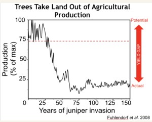
RAP can help identify yield gaps by pinpointing where woody species are reducing forage.
Landowners can see how their plant production has changed within a single month or over the span of several years. The technology can be used to visualize plant productivity in an area as small as a baseball diamond or over a landscape as large as several states.
“Basically, RAP can prevent lost revenues by showing producers where their land is less effective at growing grass. It helps ranchers put the right practices in the right places,” says Brady Allred, the researcher from the University of Montana who helped develop RAP.
Preventing trees from robbing ranchers
One of the main threats to production and profitability on western rangelands is the expansion of trees onto grasslands. From eastern redcedar destroying tallgrass prairie to juniper marching across sagebrush grazing lands, woody species are costing producers millions of dollars in lost forage.
For example, a now-forested property in Nebraska produced 0 pounds/acre of grass in 2014. But in 1985, RAP reveals that same property produced 2,200 pounds/acre of grass — before eastern redcedar consumed the once-fertile prairie.
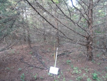
This used to be a Nebraska prairie. When woody species dominate a landscape, native grasses, shrubs, and other plants that wildlife and livestock need, can completely disappear.
“Last year, we quantified that western rangelands missed out on tens of billions of pounds of forage due to trees taking over prairies and shrub lands since 1990,” says Dirac Twidwell, rangeland ecologist at the University of Nebraska and science advisor for NRCS Working Lands for Wildlife.
This yield gap, says Twidwell is “costing producers hundreds of millions in lost revenue each year.”
Take the Flint Hills of Kansas, America’s most productive grasslands and the fourth-largest intact prairie left in the world. In 2019, RAP shows that this region produced 21.3 billion pounds of forage.
But RAP also shows that ranchers in the Flint Hills were cheated out of another billion pounds of forage in 2019 due to encroaching trees. That adds up to nearly 800,000 round-bales of hay lost last year.
Put in terms of dollars and cents, those unwanted trees cost Kansas producers $8.3 million in lost revenue in a single year.
Click here to see more...