Overview of wheat growth stage and recent low temperatures across Kansas
Based on simple wheat development models and observations from K-State Extension personnel, the wheat growth stage around Kansas ranges from tillering to Feekes 5 in the northwest part of the state, to flag leaf emergence or boot in the southeast region (Figure 1). Most of the crop in south central Kansas is at the first or second node, and the crop is less developed as we move to northwest.
For fields that have not jointed yet, the crop generally withstands temperatures of 15-20oF fairly well, especially if the growing point is still below ground. This is the condition for most of northwest and northern Kansas. If the growing point is already above ground (first joint visible), wheat can sustain temperatures down to about 24oF for a few hours. Minimum temperatures below 24oF for extended periods of time increase the risk of crop injury.
Information from the K-State Mesonet indicates that air temperatures dipped below this 24oF threshold for at least a few hours in most areas of the state, with the exception of south central and southeast Kansas. Many areas of the state experienced more than five hours with air temperatures below 24oF, which could cause damage to fields at the first node of development or more advanced stages. More advanced fields, such as second node to flag leaf emergence (such as many fields in southeast Kansas), are a little more vulnerable to freeze injury, as temperatures near the 25oF threshold can cause injury. These temperatures were also measured in south central Kansas.
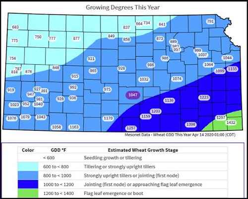
Figure 1. Estimated wheat growth stage as of April 13, 2020, for the state of Kansas. Growth stage is estimated for each county based on temperatures accumulated in the season. Local growth stage may vary with planting date and variety.
While soil temperatures can help buffer freezing air temperatures if the growing point is below ground or near the soil surface, its buffering capacity decreases as the crop develops and the growing point moves away from the soil surface. Thus, expect a positive effect of the soil temperatures in north central and northwest Kansas where soil temperatures were sustained above 38oFduring the entire week and the crop is still at tillering through Feekes 5 stages of development. Soil temperatures can be viewed via the Kansas Mesonet here: mesonet.ksu.edu/agriculture/soiltemp. However, the more advanced crop in south central and southeast Kansas likely did not benefit as much from the soil temperature buffering capacity. There was also minimal snow cover across the state to help buffer the cold air temperatures.
Predicting the level of risk for freeze injury in Kansas
Based on these factors, we estimate that a diagonal swath, encompassing parts of south central and southwest Kansa and extending into the central corridor of the state, is at the highest risk for freeze injury from the cold temperatures on April 13-17 (Figure 2). This area of high risk corresponds to areas with more advanced crop development and temperatures below the threshold for freeze damage. (Figure 2). The risk of freeze injury decreases as we move to northwest Kansas, because the crop is still behind in development; and to southeast, because the temperatures were not as cold as in central Kansas. In these regions, there is still some risk of freeze damage but this would be mainly restricted to the most advanced fields (shown as moderate risk on the risk map); for example, fields that are jointed in northwest Kansas or fields that are past the boot stage in southeast Kansas.
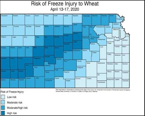
Figure 2. Estimated risk of freeze damage due to a combination of wheat growth stage sensitivity, lowest temperatures during April 13-17, 2020, number of hours below 24oF during the same period, cumulative snowfall during the period, and soil temperatures at the 2-inch depth. Map created by Erick DeWolf, K-State Research and Extension.
Symptoms of freeze injury on foliage should occur over the next few days across the entire state. In most cases, however, leaf burn injury by itself should not result in any long-term damage to the crop, especially if there is available moisture to help the crop recover the lost foliage. Freeze injury symptoms to the developing wheat head, such as a mushy discolored/brown head, take slightly longer to be visible (10-14 days). Thus, growers with fields at advanced growth stages should check for potential injury to the developing head within this timeframe.
For detailed information on evaluating wheat for freeze damage, see the eUpdate article from Issue 793 on April 3, 2020, “Potential for spring freeze injury to wheat on April 3, 2020”.
Source : ksu.edu